akmezar — kp 429
Akmezar Site report:
Görür, Muhammet; Ekmen, Hamza. 2005. Akmezer:
A Hellenistic and Medieval Settlement in Cayirli. Ankara: Gazi University Research Center for Archaeology.
Director of Erzurum Museum - Mustafa Erkmen
Faculty of Science Gazi University - Dr. Halit Çal
Archeologists - İzzet Esen (Ankara Ethnography Museum), Tolga Çelik (Konya Karatay Medresseh – Çini and Ceramic Assets Museum), Gülşah Beyazoğlu (Gazi University – Title Deed and Cadastral Proficiency School), Belgin Savaş, Resul İbiş, Atakan Akçay Arş. Gör. Candaş Keskin, Özgür Öztürkler, H. Osman Alkan, Yunus Muluk, Yunus Ayata, H. Bayhan Topçu, Gökhan Yıldız and Hüsnü Genç (Gazi University – Archeological Environment Assets Research Center)
Geophysical Research - M. Özgü Arısoy
Technical Ceramic Evaluators - Yunus Ekim, Hamza Ekmen and Z. Filiz Bilir
Architectural and Small Findings Drawings - Hamza Ekmen, Yunus Ekim, Resul İbiş and Emsal Koçerdin
Photography & Computer Adjustments - Emrah Karakurum
Archiving & Cataloging - Yunus Ekim, Hamza Ekmen and Z. Filiz Bilir
Büyükardıç — kp 270
Bartl, K. “Eastern Anatolia in the Early Iron Age”, J. Eichman and H. Parzinger (eds.), Migration und Kulturtransfer. Der Wandel vorder-und zentralasiatischer Kulturen im Umbruch vom 2. zum 1. vorchristlichen Jahrtausend. Acten des Internationalen Kolloquiums. 23-26 November 1999 Berlin. Bonn: 383-410.
Büyükardıç Site report:
Şenyurt, S. Yücel. 2005. Büyükardıç:
An Early Iron Age Hilltop Settlement in Eastern Anatolia. Ankara: Gazi University Research Center for Archaeology.
Director of Erzurum Museum - Mustafa Erkmen
Faculty of Architecture and Engineering, Gazi University - Dr. Nakış Akgül
Zonguldak Ereğli Museum - Yalçın Yılmazer
Department of Anthropology, Ankara University - Hakan Yılmaz and Ayşen Açıkkol
Gazi Üniversitesi Tapu-Kadastro Meslek Yüksek Okulu - Gülşah Beyazoğlu
Department of History of Arts, Selçuk University - Hakan Tekin
Archeologists, Gazi University - Atakan Akçay, Resul İbiş, Hamza Ekmen, Erkan Atay, Mithat Gür, Filiz Canyurt, Ferya Aktaş, Atahan Çiçek, Yunus Derdiyok, Uğur Abaza, Erdem Güngör, Yunus Ayata, Gökhan Yıldız, Emrah Karakurum (restoration)
Technical Ceramic Drawings - Hamza Ekmen, Resul İbiş, Emrah Karakurum, Göknil Arda, Z. Filiz Bilir, Melike Hakverdi
Statistical Evaluations - Atakan Akçay and Yalçın Kamış
Technical Architectural & Small Finds Drawings - Hamza Ekmen, Resul İbiş and Emsal Koçerdin
Photography & Computer Adjustments - Emrah Karakurum and Atakan Akçay
Archiving & Cataloging - Atakan Akçay, Yalçın Kamış and Göknil Arda
Appendix I Authors - Ayşen Açıkkol and Hakan Yılmaz
Appendix II: XRF Analysis of Pottery - Dr. Pervin Arıkan, Burcu Ender (Faculty of Science and Literature, Department of Physics, Gazi University), Abdullah Zararsız (Ankara Nuclear Fusion Laboratory, Turkish Atomic Energy Authority)
Güllüdere — kp 354
Derin, Z. Demir. Çağ’da Anadolu’da Ölü Gömme Gelenekleri. Ege Üniversitesi Sosyal Bilimler Enstitüsü (Basılmamış Doktora Tezi), İzmir. 1993. p189.
Seher. J. Seher, “Tod und Bestattung in der Vorgeschichte/Tarih Öncesi Çağlarda Ölüm ve Gömü”, Arkeoloji ve Sanat 59, İstanbul: 2-8. 1993. p 12.
Sevin, V. et al. V. Sevin, A. Özfırat ve E. Kavaklı, “Van-Karagündüz HöyüğüKazıları (1997 Yılı Çalışmaları)”, Belleten 63: 847-867. 1999. p856.
Güllüdere Site report:
Şenyurt, S. Yücel; İbiş, Resul. 2005. Güllüdere:
An Iron Age and Medieval Settlement in Askale Plain. Ankara: Gazi University Research Center for Archaeology.
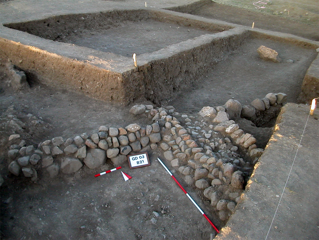
Güllüdere settlement was first identified during the surveys carried out by Gazi University Archaeological Heritage Management and Implementation Unit - in 2002, within Basic and Detailed Engineering Study Phases of BTC Crude Oil Pipeline Project . Güllüdere salvage excavations have been carried out between July 2, 2003 and October 25, 2003 together with the excavation team gathered by Gazi University Research Center for Archaeology (GÜ-ARÇED), with the financial support of BTC Crude Oil Pipeline Project Directorate and by the permission of the Cultural Assets and Museums General Directorate of Ministry of Culture and Tourism - within BTC Crude Oil Pipeline Archeologic Salvage Excavations Project.
Director of Erzurum Museum - Mustafa Erkmen
Faculty of Science and Literature, Gazi University - Dr. Hakkı Acun
Elazığ Museum - Serdar Okur
Aydın Museum - Mehtap Ateş
Department of Anthropology, Ankara University - Hakan Yılmaz and Ayşen Açıkkol
Archeologists, Gazi University - Gülşah Beyazoğlu, Dr. Nurşen Özkul Fındık (Asst. Prof. Gazi University Department of History of Arts), Hakan Çetin, H. Kamil Biçici, Esra Yıldız, Serkan Sunay and Murat Çerkez, Atakan Akçay, Resul İbiş, Hamza Ekmen, Mahmut Polat, Filiz Azeroğlu, Zeynep Yılmaz, Yalçın Çelik, Ersoy Köse, Cüneyt Has, Ruşen Taşdöğen, Erdem Güngör, Gürbüz Beydiz, Serkan Erdoğan, Murat Ateş, Şirin Kaya (Restoration)
Technical Ceramic Evaluation - Resul İbiş, Hamza Ekmen, Atakan Akçay and Yalçın Kamış
Technical Architectural & Small Finds Drawings - Hamza Ekmen, Resul İbiş and Emsal Koçerdin
Photography & Computer Adjustments - Emrah Karakurum and Atakan Akçay
Archiving & Cataloging - Atakan Akçay, Yalçın Kamış and Yalçın Kamış
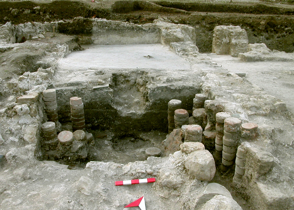
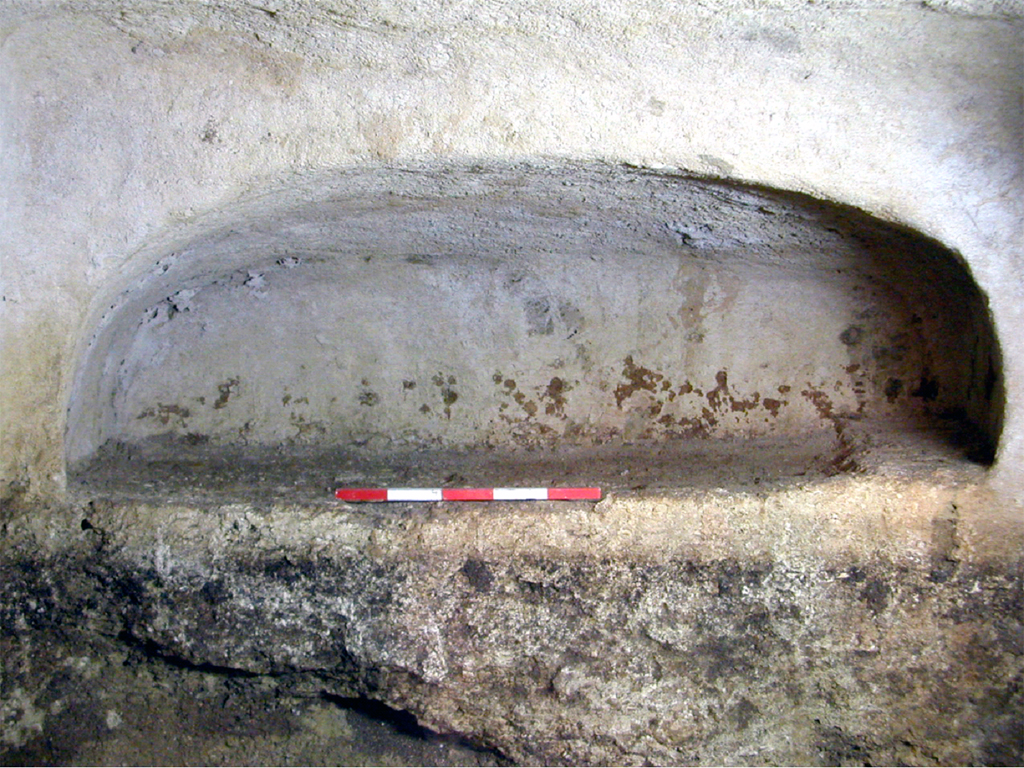
KAYRANLIKGÖZÜ — kp 922
Nielsen, I.1993. Thermae et Balnea. Cilt.2, Denmark.
Yegül, F.K. 1992. Baths and Bathing in Classical Antiquity. New York.
Kayranlıkgözü Site report:
Görür, Muhammet. 2005. Kayranlık:
A Roman Bath in Eastern Kilikia. Ankara: Gazi University Research Center for Archaeology.
Salvage Excavation - Muhammet Görür (Gazi University Research Center for Archaeology)
Director of Kahramanmaraş Museum - Ahmet Denizhanoğulları
Archeologists - Sibel Arslan, Mustafa Kırdı, Elif Yüce, Zeynep Yılmaz, Volkan Canbulat, Tuba İbiş, Yunus Ekim, Resul İbiş, Hamza Ekmen, Semih İstanbulluoğlu, Gülşah Beyazoğlu (Jeodesi expert)
minnetpinari — kp 986
Minnetpinari Site report:
Tekinalp, V. Macit. 2005. Minnetpinari:
A Medieval Settlement in Eastern Kilikia. Ankara: Gazi University Research Center for Archaeology.
Director of Kahramanmaraş Museum - Ahmet Denizhanoğulları
Gaziantep Museum - Taner Atalay
Lead Archaeologist, Gazi University - Dr. Halit Çal
Deputy Archaeologist - Dr. Muhammet Görür
Archeologists, Gazi University - Engin Yüksel, Özgür Giray, Mustafa Kırdı, Uğur Turan Kınacı, Özlem Balkozak, Dilem Köse, Ayşegül Özkan, Sibel Arslan, Halim Kes, Bülent Demir, Çiğdem Özkan, Ünver Göçen, Elif Yüce, Perihan Kösem and Hayati Uğur
Art Historians - Sıdıka Taşkın and Yunus Muluk
Anthropologist - Hakan Yılmaz
Geologist - Gülşah Beyazoğlu
Restoration - Erkan Baloğlu and Şirin Kaya
sazpegler — kp 040
Erinç, Sırrı. 1953. Doğu Anadolu Coğrafyası. İstanbul 1953. p97.
Hopkins, Liza. 2003. Archeology at The Nort- East Anatolian Frontier, VI An Ethnoarchaeological Study of Sos Höyük and Yiğittaşı Village. Paris: Peeters Press 2003.
McNicholl, Anthony. 1983. Taşkun Kale Keban Rescue Excavations, Eastern Anatolia, British Institute of Archaeology at Ankara, Monograph No. 6, BAR International Series 168. Ankara 1983. fig. 48 no. 25- KP I/ II ?, fig. 55 no. 68- KP I, fig. 56 no. 77- KP I ?, fig. 50 no. 39- KP I/ II.
Meskhia, SH A. 1968. An Outline of Georgian History. Tbilisi: Tbilisi University Press 1968. p12-13.
Moore, John. 1993. Tille Höyük 1: The Medieval Period. British Institute of Archaeology at Ankara, Monograph no: 14, Ankara 1993. fig. 28 no. 4- Level 2.1- 2.2.
Sagona, Antonia & Sagona, Claudia. 2004. Archaeology at the North-East Anatolian Frontier, I: An Historical Geography and Field Survey of the Bayburt Provience, Ancient Near Eastern Studies Supplement 14. Belgium: Peeters 2004. fig. 121 no. 8.
Sözer, Ahmet Necdet. 1972. Kuzeydoğu Anadolu’da Yaylacılık. Ankara: İş Matbaacılık 1972. : fig. 121 no. 8. fig. 152 no.11. (Sözer 1970: 44)
Sazpegler Site report:
Tekinalp, V. Macit.; Ekim, Yunus. 2005. Sazpegler:
A Medieval Settlement in North Eastern Anatolia. Ankara: Gazi University Research Center for Archaeology.
Director of the Kars Museum - Necmettin Alp
Faculty of Language, History and Geography, Ankara University - Dr. Kadriye Özçelik
Faculty of Science and Literature, Çukurova University - Fatma Şahin
Cartography - Gülşah Beyazoğlu (Gazi University Vocational High School of Land Survey)
Archeologists, Gazi University - Nurcan Havare, Ferit Coşkun, Emel Ayan, Bülent Demir, Onur Yılmaz, Levent Çelik, Kemal Dedeoğlu, Şener Yıldırım, Ece Benli and Ersoy Köse
Ethnographical Museum of Ankara - İsmail Duran Geophysical Analysis - Özgü Arısoy
Technical Ceramic Drawings - Hamza Ekmen, Resul İbiş and Emsal Koçerdin
Technical Architectural & Small Finds Drawings - Hamza Ekmen, Resul İbiş and Emsal Koçerdin
Restoration - Akbil Bengül
Photography & Computer Adjustments - Ahmet Okur
Statistical Analysis - Z.Filiz Bilir
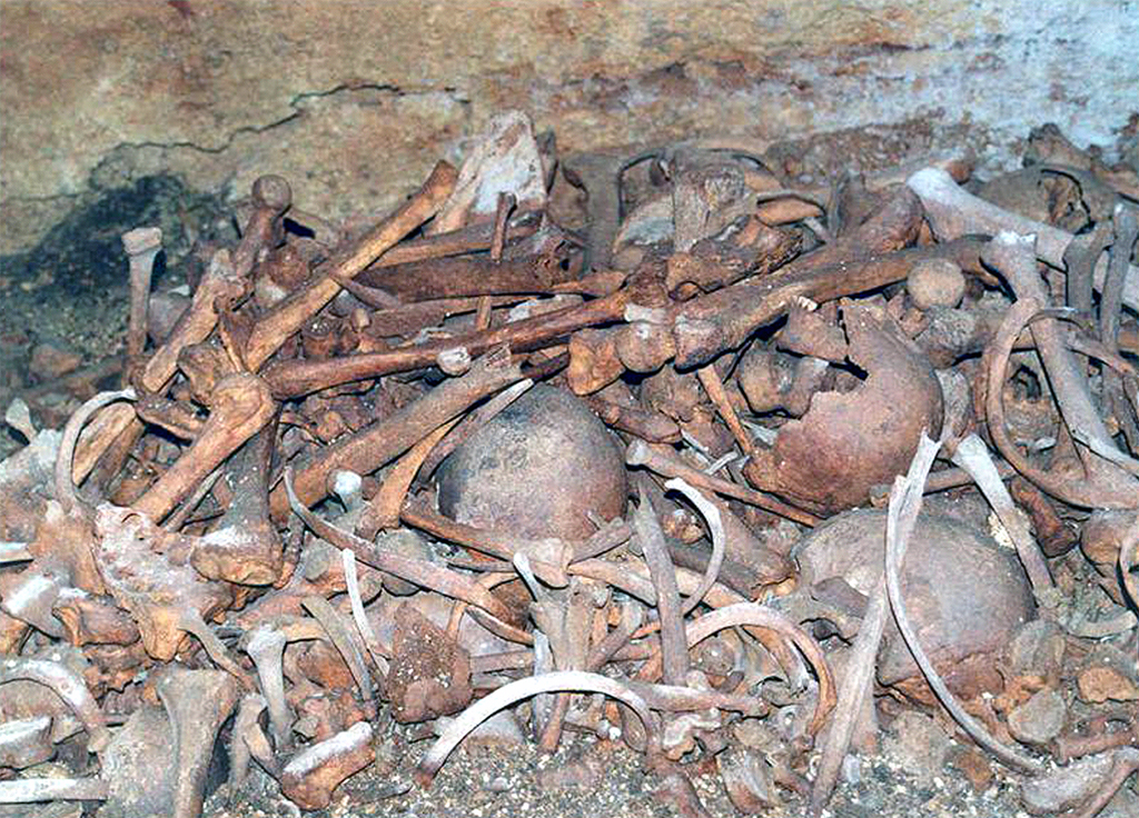
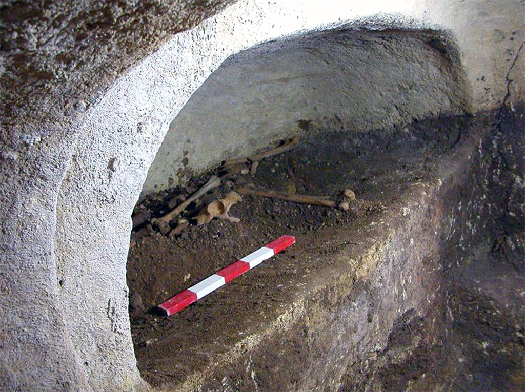
tasmasor — 299
Sagona C. 2004. “Literary Tradition and Topographic Commentary”, IN A. Sagona and C. Sagona, Archaeology at the North-East Anatolian Frontier, I. An Historical Geography and a Field Survey of the Bayburt Province. Ancient Near Eastern Studies Supplement 14. Louvain-Paris-Dudley, MA.:25-71.
Tasmasor Site report:
Şenyurt, S. Yücel. 2005. Tasmasor:
An Iron Age Settlement in Erzurum Plain. Ankara: Gazi University Research Center for Archaeology.
Director of Erzurum Museum - Mustafa Erkmen
Faculty of Science, Hacettepe University - Dr. Bora Uysal, Dr. Selim Erdal (Human Skeletons)
Faculty of Science and Literature, Gazi University - Dr. Yücel Şenyurt
Archeologists - Hamza Ekmen, Yunus Ekim, Atakan Akçay, Resul İbiş, Belgin Savaş, Göknil Arda, Z. Filiz Bilir, Emsal Koçerdin, İ. Ernur Öztekin, Sibel Akcan, Bedriye Koçak, Gülsüm Şanalır, Elif Yüce, Müge Küçük, Nuran Ökse, Duygu Tuncay, Uğur Abaza, Sıraç Karadağ, Tuba İbiş, Özlem Balkozak, Özgür Giray, Halim Kes, Mustafa Kırdı, Mahmut Polat, O. Hamza Kaycı, Hünkar Keser, Farahnaz Ansari Meşhur and Döndü Topçu
Anthropologists - U. Güney Arıkan, Serpil Eroğlu and Barış Özener
Restoration - Emrah Karakurum
Geodesy expert - Gülşah Beyazoğlu
Geophysical expert - M. Özgü Arısoy
tetikom — kp 292
Badaljan, R. S. 1994. “Preliminary Report on the 1993 Excavations at Horom, Armenia”, Iran 32: 1-29. p6, 8-10, Fig.8.
Belli, O. & Konyar, E. "Doğu Anadolu Bölgesi’nde Erken Demir Çağı Kale ve Nekropolleri." Arkeoloji ve Sanat Yayınları, İstanbul. p23, Fig. 8, Çiz. 17.
Güneri, S. 2005. “Erzurum Bulamaç Höyük Kazıları 2001-2002 Yılı Çalışmalarına Ait Rapor”, Arkeoloji, Anadolu & Avrasya 1: 99-139. p101.
Sagona, A. 2003. “The Upper Levels at Sos Höyük, Erzurum: A Reinterpretation of the 1987 Campaign”, Anatolia Antiqua 11: 101-109. p104.
Tetikom Site report:
Şenyurt, S.Yücel; Ekmen, Hamza. 2005. Tetikom:
An Iron Age Settlement in Pasinler Plain. Ankara: Gazi University Research Center for Archaeology.
Director of Erzurum Museum - Mustafa Erkmen
Faculty of Science and Literature, Gazi University - Dr. Yücel Şenyurt, Murat Albecer
Erzurum Museum - Birol Güngör
Anthropology Department, Ankara University - Hakan Yılmaz, Ayşen Açıkkol
School of Title Deed, Gazi Universiy - Gülşah Beyazoğlu
Archaeological Research Center, Gazi University - Cadastre, Atakan Akçay, Belgin Savaş, Resul İbiş, Hamza Ekmen, Orkun H. Kaycı, Gülsüm Şanalır, Bedriye Koçak, Bilge Gülsoy, Gülşah Altunkaynak, Hayati Uğur, Yunus Muluk, Burcu Yarar, Cem Cıvaoğlu, Ali Yalın Turan, Tülin Kaya, Yonca Acem, Belgin Aksoy, U.Ezgi Oktay, H.Osman Alkan, Harun Bayhan Topçu, Fatih Yıldırım, Uğur Abaza, Erdem Güngör
Restoration - Emrah Karakurum, Erkan Baloğlu
Geophysical Research - M. Özgü Arısoy
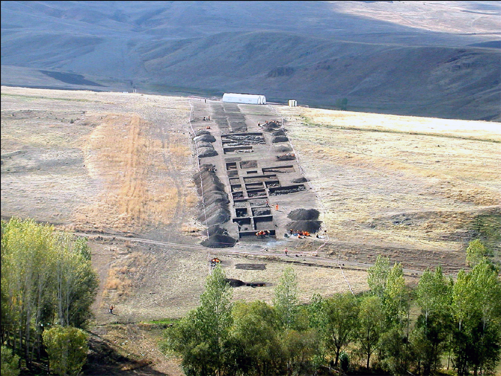
Yüceören — kp 1096
Broneer, O. “Terracotta Lamps”, Corinth IV. 2, Cambridge, MA.1930. p120-121, pl.23, No.1501-1509.
Christensen, A. P. & Johansen, C. F. “HAMA, Fouilles et Recherches de la Fondation Carlsberg 1931 - 1938”, Les Poteries Hellénistiques et les Terres Sigillées Orientales Nationalmuseet, Copenhagen. 1971. fig.23/201, 207, 208; figs.23/206, 202, 204; Öztürk 2002: fig.5, drw.5.
Goldman, H. Excavations at Gözlükule, Tarsu:, The Hellenistic and Roman Period, Volume I, New Jersey. 1950. pl. I: figs.137-298, 297. figs.189-298; Öztürk 2002: fig.5, drw.5; Hayes 1991: fig. XLVII/84.
Menzel, H. Antike Lampen im Römisch-Germanischen Zentralmuseum zu Mainz, Mainz. 1954. abb. 82.
Rosenthal, R. & Sivan, R. “Ancient Lamps in the Schloessinger Collection”, Qedem 8: 22 - 25. 1978: 141, fig.578-581. Goldman. 1950: pl.I: figs.135-225, 247, 249 figs.187-225, 224-F;
Waage, F. O. 1941-1948. “Hellenistic and Roman Tableware of North Syria”, Antioch on the Orontes IV, Part I: Ceramics and Islamic Coins, Princeton. This citation has a small discrepancy in the dates 1941 vs. 1948.
Walters, H. B. Catalogue of the Engraved Gems and Cameos Greek, Etruscan and Roman in the British Museum, London. 1926. no. 2420.
Yüceören Site report:
Şenyurt, S.Yücel; Akçay, Atakan; Kamiş, Yalçin. 2005. Yüceören:
A Hellenistic and Roman Necropolis in Eastern Kilikia. Ankara: Gazi University Research Center for Archaeology.
The Yüceören Necropolis Salvage Excavation was executed by GÜ-ARÇED. The Middle East Technical University Centre for Research and Assessment of the Historic Environment (METU-TAÇDAM) and the Gazi University Archaeological Heritage Management and Execution Unit (later Gazi University ARÇED) conducted field surveys at Yüceören in 2001 and 2002 under the BTC Crude Oil Pipeline Project Basic and Detailed Engineering Phase program. Both institutions are in the process of publishing the scientific results of those surveys.
Director of the Adana Museum - Kazım Tosun
Faculty of Arts and Science, Gazi University - Dr. İlhami Durmuş
Field Excavation Director - Dr. L. Gürkan Gökçek
Archaeologists - Atakan Akçay, Yunus Ekim, Emsal Koçerdin, H.Koray Akıncı, O.Hamza Kaycı, Emrah Çankaya, Zeynep Yılmaz, E.Korkut Erbil, Evren Türkmenoğlu, Bülent Ateş, Müjde Yazar, Öznur Kuş, Gülşen Yağcı, Ersoy Köse, Ferit Coşkun, Bilge Gülsoy, Tarık Özbek, Günnur Çil, U.Tolga Gürsoy
Restoration - Şirin Kaya
Geodesy Expert - Gülşah Beyazoğlu
ziyaretsuyu — kp 714
Batonishvili, Vakhushti. 1973. "Description of the Kingdom of Georgia." Kartlis Tskhovreba. IV, Tbilisi, p. 42.
Berdznishvili, M. 1979. 12th Century Georgian Historical Sources. Tbilisi, p. 60. (in Georgian)
Chkhartishvili, M. 1969. About the History of Glass Production in Middle Ages Rustavi. I, Tbilisi, p. 145. (in Georgian)
Chkhartishvili, M. 1964. "A Peculiar Type of Rustavi Middle Ages Unglazed Ceramics." Matsne. No 5, p. 166.
Chilashvili, L. 1975. Old Gavazi. Tbilisi, p. 21-23. (in Georgian)
Japaridze, V. 1956. Ceramic Production in Georgia from Tenth to Thirteenth Centuries. Tbilisi, p.17. (in Georgian)
Ramishvili, R. 1970. Archaeological Monuments of Iori Valley, I: Sioni. Tbilisi, p. 93. (in Georgian)
Ramishvili, R. 1974. Iaghsari Ancient Settlement and the Mlasheebi Gori Wine-cellar, II. Tbilisi, p. 140.
Rcheulishvili, G. 1990. Medieval Archaeological Monuments of Pshavis Aragvi Gorge. Tbilisi. (in Georgian)
Rcheulishvili, G. 1981. "Archeological Investigation at Khertvisi Tower." Zhinvali Expedition. Tbilisi. (in Georgian)
Rcheulishvili, G. 1977. "Wine-presser of Aragvi Gorge." Archeological Investigations. Tbilisi. (in Georgian)
Atskuri Winery site report:
Licheli, Vakhtang ; Rcheulishvili, Giorgi; Kasradze, Merab; Rusishvili, R.; Kalandadze, Nino; Papuashvili, Nana; Kazakhishvili, L.; Gobejishvili, Gela. 2007.
Archaeological Investigation at Site IV- 266/320, KP211/212, Atskuri Village, Akhaltsikhe Region. Tbilisi, Otar Lordkipanidze Centre of Archaeology of the Georgian National Museum.
Gazi University Research Center for Archaeology (GÜ-ARÇED) - Dr. Meral Ortaç
Director of the Sivas Museum - Süheyla Demirci
Sivas Museum - Mehmet Alkan
Archaeologists - Mahmut Polat, Gökhan Yıldız, Bedriye Koçak, Fetullah Yurttaş, Semih İstanbulluoğlu, Müge Küçük
Restoration - Sezen Bozkır & Emrah Karakurum
Architectural Drawings - Resul İbiş, Hamza Ekmen, Yunus Ekim, Atakan Akçay